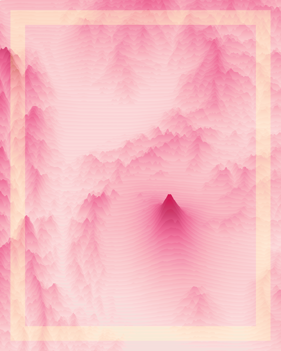
Voyager #1 | Mt Fuji – Japan
This unique piece is a geovisualisation of the Mount Fuji and its area.
Dimensions: 8000x10000
Edition: 1/1
Year: 2021
Data: SRTM 1 Arc-Second Global (satellite imagery)
Coordinates: N 35° 27' 33.48 | E 138° 41' 24.36
Any owner of this work can request a full explanation of how data was used in its creation, if they wish to know.
Made with QGIS, Illustrator and D3.js
Details
Created
Oct 12th, 2021, 08:09
Blockchain
ETH
Storage
centralized
Token standart
ERC-721
Metadata
Unlockable content
No
Rarity
Rarity score
N/A
Rarity rank
N/A / 130767
Trait count
0
What is the value?
Price
Sales
Sales (All)
N/A
Avg collection sales (All)
N/A
Difference
N/A
Collectible last sale price
--
Collection avg price (All)
--
Difference
N/A
Collectible last sale price
--
Collection min price (All)
--
Difference
N/A
Successful royalty payments
--
Skipped royalty payments
--
Difference
N/A
Activity history
Processing data. Please, come back later.
Critical Risk
Details
Centralized storage
Foundation Storefront
0 sales per last month
Editable metadata stored on a server
Decentralized storage
Collection tokens130767 tokens
Unique Owners18396 / 14.06%
0%
ERC-721
0 potential sales
0% missed royalty fee
The original collection.
Found 0 similar collections
More from Foundation (FND)
| # | NFT | 7D CHANGE |
|---|
Showing 1-10 out of 130,766
Rows per page
10