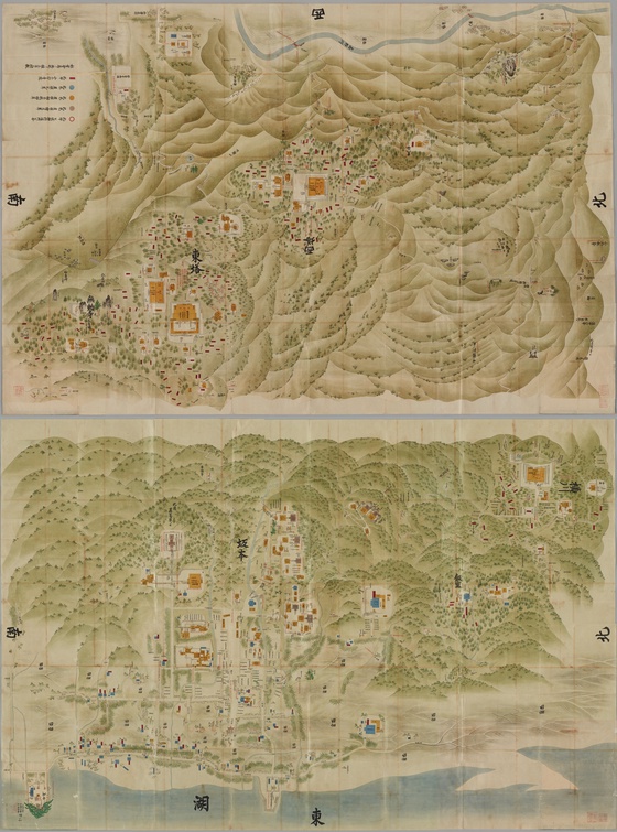
Sanmon-Santō Sakamoto Sōezu 1st & 2nd volume 山門三塔坂本惣絵図 第1鋪 & 第2鋪
Sanmon-Santō Sakamoto Sōezu (Japanese: 山門三塔坂本惣絵図) is the two old maps (1st & 2nd volume) that shows the precincts of Enryakuji Temple on Mt. Hiei-zan and Sakamoto area at the foot of Mt. Hiei-zan, Otsu City, Shiga Prefecture, Japan. The maps was made in 1767 (the middle of the Edo period, Japan). The author is unknown.
- The 1st volume of the maps shows Yokawa area in the precincts of Enryakuji Temple on Mt. Hiei-zan and Sakamoto area at the foot of Mt. Hiei-zan.
- The 2nd volume of the maps shows Tō-dō area and Sai-tō area in the precincts of Enryakuji Temple on Mount Hiei.
Enryakuji Temple is registered as a UNESCO World Heritage Site as one of the 17 temples and shrines that make up th...
Details
Created
Jul 10th, 2022, 12:09
Blockchain
ETH
Storage
centralized
Token standart
ERC-721
Metadata
Unlockable content
No
Rarity
Rarity score
N/A
Rarity rank
# 1 / 1
Trait count
2
What is the value?
Price
Sales
Sales (All)
N/A
Avg collection sales (All)
N/A
Difference
N/A
Collectible last sale price
--
Collection avg price (All)
--
Difference
N/A
Collectible last sale price
--
Collection min price (All)
--
Difference
N/A
Successful royalty payments
--
Skipped royalty payments
--
Difference
N/A
Activity history
Processing data. Please, come back later.
Critical Risk
Details
Centralized storage
Centralized storage
0 sales per last month
Editable metadata stored on a server
5%
Custom contract
ERC-721
Collection tokens1 tokens
Unique Owners1 / 100%
0 potential sales
0% missed royalty fee
The original collection.
Found 0 similar collections
More from Yukinobu Kurata Library
| # | NFT | 7D CHANGE |
|---|
Showing 1-10 out of 0
Rows per page
10